
Stay ahead of the curve with our weekly guide to the latest trends, fashion, relationships and more
Stay ahead of the curve with our weekly guide to the latest trends, fashion, relationships and more
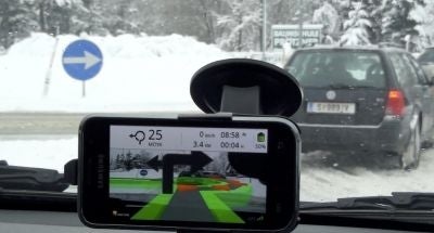
Wikitude Drive, the first augmented reality navigation application for vehicles, has officially launched in the US.
The app, which overlays turn-by-turn navigation onto a display of the road ahead generated using a smartphone's camera, launched July 19 in the Android Market priced $9.99.
Now, the software will be available for US Android users, with the company promising that US drivers will find following a line on their phone screen far easier than following one on an "abstract map."
Like competing apps available from providers such as TomTom and Garmin, users can also add points of interest such as hotels, restaurants and petrol stations to the display.
Wikitude Drive has been available in Europe (Austria, Germany, Switzerland, UK, Spain, France, and Italy) since earlier this year, launching to mixed reviews from users.
However, the beta-version of the software has already won several prizes, including from the European Satellite Navigation Competition and the satellite navigation provider Navteq.
Subscribe to Independent Premium to bookmark this article
Want to bookmark your favourite articles and stories to read or reference later? Start your Independent Premium subscription today.
Join our commenting forum
Join thought-provoking conversations, follow other Independent readers and see their replies